
Infrastructure is the datum.
Roads, grading, drainage, utilities , concept through construction. The model every discipline coordinates against, accurate from day one.


Infrastructure modelling without the resource bottleneck
Production capacity without hiring
Road designers, drainage modellers, and utility coordinators from one studio. No recruitment. Capacity matched to your infrastructure programme.
Same standard, every engineer
ACA quality gates on every grading surface, pipe network, and road alignment. ERP-tracked. Same standard across every infrastructure package.
Single point of accountability
One team from grading through utilities. No coordination gaps between your civil model and every building that connects to it. One responsibility matrix.
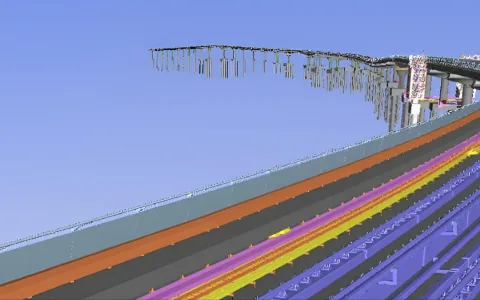
Civil in production
Six views from live civil packages, federated site models, road corridors, drainage networks, grading surfaces, utility coordination, and earthworks phasing.
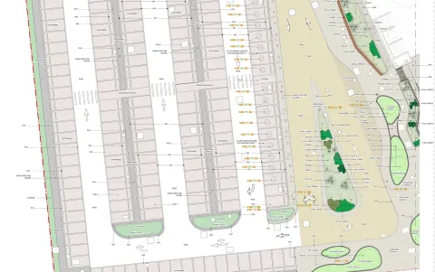
Get the civil drawing pack.
Real civil drawings from completed projects: general arrangement plans, drainage and road layouts, grading surfaces and adoption-ready records. The drawings we actually issue, not a brochure, so you can judge the standard before you brief anyone.
- Contents
- 4 documents · PDF + Civil 3D / LandXML samples
- Drawn from
- Completed civil packages, redacted
- Audience
- Civil Managers · BIM Coordinators · Main Contractors
Feasibility through adoption. One team
Three phases. Click any to expand the key processes, deliverables, and BIM requirements at that stage.
From topographic survey integration to fully coordinated civil infrastructure models. We develop grading, drainage, roads, and utilities designs that integrate with building and landscape models from the earliest project stage, so every design discipline shares a single baseline.
Key processes
Survey data integration
Point clouds, topographic surveys, and existing utility records imported into Civil 3D with coordinate system alignment to project grid, so your design foundations are accurate from day one.
Grading and drainage modelling
Finished floor levels, platform levels, drainage networks, and pipe sizing coordinated across all disciplines, so conflicts are resolved in the model before earthworks begin.
Multi-discipline coordination
Civil surfaces and networks shared as linked references with architecture, structure, and landscape models at each design stage gate.
Deliverables
- Topographic survey integration model
- Grading & earthworks design (LOD 200)
- Road alignment & cross-sections
- Cut & fill volume calculations
- Stormwater drainage network model
- Foul drainage & sewer layouts
BIM requirements
Survey & Utilities
Topographic data and utility records digitised with confidence levels per utility survey standard. Coordinate system and tolerances defined before design starts.
Surface Modelling
Existing ground and proposed design surfaces modelled to 50mm vertical accuracy, verified against survey benchmarks at every design stage submission.
Data Exchange
IFC and LandXML exports validated for cross-platform interoperability. Civil 3D corridors and pipe networks exported with full attribute data intact.
Construction-ready civil infrastructure models with setting-out data, machine control surfaces, and fully resolved utility coordination, enabling accurate earthworks, drainage installation, and road construction across every discipline.
Key processes
LOD 400 model development
Construction geometry with pipe invert levels, manhole details, kerb profiles, and sub-base layers modelled to installation tolerance, so contractors have exact dimensions for procurement and sequencing.
Machine control surface export
Finished grading surfaces and sub-formation surfaces exported in LandXML format for GPS-guided earthworks and paving equipment, so positioning is accurate to within design tolerance.
Utility coordination and protection
Existing and proposed utilities modelled with clearance zones, crossing details, and protection measures coordinated with statutory undertakers.
Deliverables
- Construction-issue civil model (LOD 400)
- Machine control surfaces (GPS grading)
- Setting-out coordinate schedules
- Drainage construction longsections
- Road construction detail packages
- Temporary works & phasing plans
BIM requirements
Setout & Machine Control
Coordinates extracted at 10mm precision. Surfaces exported in LandXML, TIN, and manufacturer formats validated against design intent.
Drainage Compliance
Drainage designs verified against SfA or local authority standards. Gradients, cover depths, and manhole spacing per specification.
Temporary Works
Temporary structures modelled with design life and load capacity. Removal sequencing documented per CDM requirements.
As-built civil infrastructure verified against installed conditions, adoption-ready documentation packages, and asset data for highways authorities and utility adopting bodies, so handover is clean and complete.
Key processes
As-built verification
Civil model updated from contractor survey data, CCTV drainage surveys, and GPS as-built records for all roads, drainage, and utility installations, so the model matches the ground.
Adoption documentation
Drainage records prepared per Water Authority requirements with manhole schedules, pipe runs, invert levels, and contributing area calculations, ready for authority sign-off.
Highway records and asset tagging
Road construction details, kerb alignments, footpath widths, and lighting column positions documented per adopting authority submission requirements with material type and design life embedded.
Deliverables
- Verified as-built civil model (LOD 500)
- CCTV survey correlation reports
- Adoption-ready drainage records
- Highway adoption documentation
- Asset register for adopted infrastructure
- Model handover audit report
BIM requirements
Accuracy & Adoption
As-built model verified within 25mm horizontal / 10mm vertical. Drainage records per Water Authority template, ready for approval.
Asset Classification
Assets classified per UKPMS or adopting body schema. Material type, condition grade, design life, and maintenance responsibility tagged.
Handover Format
Civil 3D + LandXML + IFC + PDF record drawings + GIS shapefiles per employer info and adopting authority standards.
Validate cut and fill before breaking ground
Excavation, road construction, and utility routing phased against the model. Cut and fill volumes and earthwork budgets validated. Site logistics modelled. Reduces excavation surprises and change orders.
4D Earthworks Sequencing
Excavation phasing, haul routes, and equipment positioning tied to the model. Validated before breaking ground. Avoids access conflicts and rework.
5D Earthworks Quantities
Cut and fill volumes and stockpile calculations extracted from the model. Budget validated before procurement. Track costs in real time.
Logistics Planning
Site access, delivery sequences, and phased handover modelled. Minimises trade congestion and waiting time. Keeps the critical path moving.
Civil work we've coordinated
Roadworks, drainage, utilities and earthworks coordinated against the building model from schematic design through adoption. Infrastructure modelled as the datum, with every other discipline referencing it.

Al Badia
Every consultant and contractor on Al-Futtaim's master-planned villa and low-ris…
Read the case
Marsa Al Arab
Five disciplines on one hospitality tower, architecture to marine works, federat…
Read the case
Six Senses Red Sea
Geometrically expressive resort architecture and luxury villas on a remote Red S…
Read the case
Qiddiya Water Theme Park
Pools, ride mechanical and themed landscape services federated in one model acro…
Read the case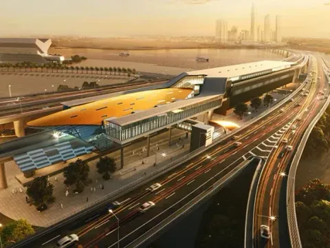
Dubai Metro Route 2020
An Expo-line metro extension coordinated through depot facilities, station boxes…
Read the caseFrom the journal
Field notes on civil delivery.
 6 min
6 min
From LOD 350 to fabrication-ready
Why "coordinated" models still cause site rework, and the handoff that fixes it.
Read 5 min
5 min
The BEP subcontractors actually follow
The difference between a filed document and a working agreement is five sections.
Read 5 min
5 min
Clash detection to zero
Zero hard-clash is table stakes. Here is the tolerance standard we hold a federated model to before sign-off.
Read 6 min
6 min
QTO as the single source of truth for variations
When quantities come straight from the model, variations stop being arguments and become deltas.
Read 5 min
5 min
As-built from day one
Retrofitting an as-built at practical completion is a tax. Updating it weekly is a habit.
Read